
Pilot-Report EDNY to LOWI

This is a Pilot-Report on one of my first flights as Pilot in Command on the Cirrus SR20G2 from Friedrichshafen (EDNY) to Innsbruck (LOWI) in 2010 ...
After engine start we received the Automatic Terminal Information Service (ATIS) with information R at time 13:55 UTC. The METeorological Aerodrome Report (METAR) was - SAENDY 22012010Z 24005KT 9999 FEW009 BKN015 02/M01 Q1009 NOSIG.
As can be seen a broken (5-7/8) cloud cover was reported at 1500 ft above aerodrome level (QFE) - so I confirmed myself on initial call by the tower (TWR) controller that a VFR departure is possible. He affirmed and cleared us from our parking position on apron number 3 to the holding point for runway 06 via taxiway N and F. Thereafter we should fly a VFR departure via the VFR reporting point S and squawk 0003.
After the takeoff rotation we started turning left over the threshold of RWY 24 direct to S. We had to lower our initial climb gradient to stay clear of clouds until reaching a small "window" within the cloud base through which we continued our climb at maximum rate. Reaching the top of clouds at an altitude of about 4000 ft QNH we were out of the control zone of Friedrichshafen (EDNY). After leaving frequency of EDNY TWR we switched to Munich Information and squawked 7000. I requested a Met-Report from Innsbruck to evaluate the weather conditions to be expected at arrival in LOWI.
The flight was calculated with an inbound course to Kempten VOR on radial 072° (e.g. QDM 072) and uppon reaching with an outbound course from Kempten on radial 132° (e.g. QDR 132) inbound to Reutte (LOIR). At the 252° radial and DME 18NM of KPT VOR we left the Transponder Mandatory Zone (TMZ) of ENDY. At about DME 15NM from KPT we started to transit from radio navigation (VOR) to GPS navigation (GNSS) to intercept the track from KPT to LOIR at an angle of 45° (e.g. a ground track of 087° was established). After interception and short before entering the Flight information Region (FIR) Wien we left Munich Info frequency. We were passing LOIR at 8500 ft on QNH 1008 (obtained from Munich Info) and I disconnected the auto pilot to manually fly the airplane on our predefined route through the valleys towards LOWI.
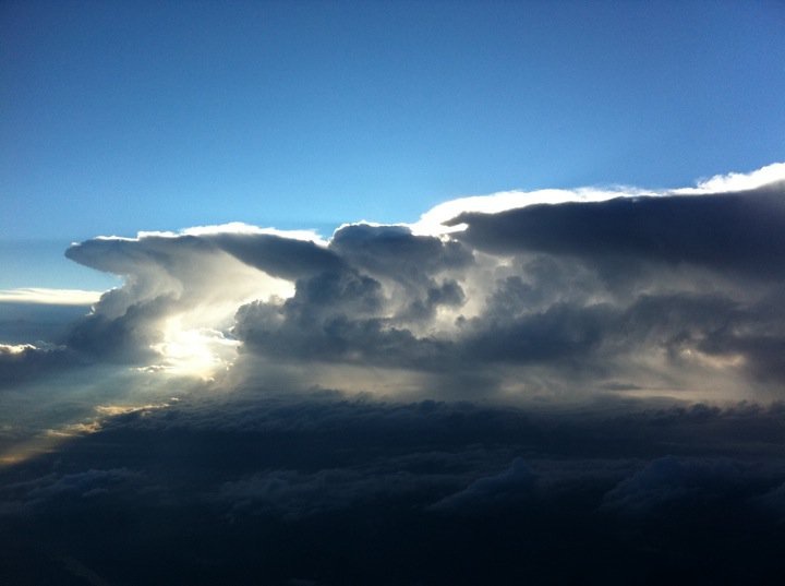
The weather enroute was partially cloudy with broken clouds at about 5000 ft enroute to Kempten (see pictures) and far more dense cloud base with overcast at 4000-5000 ft QFF enroute to LOWI. The wind in about 8000 ft was 030V12005KT without any turbulence with a clear sky and visibility of mote than 50NM. As reported from Munich Information a Cessna 172 were north of LOIR initially in out 2 o'clocks position at a distance of about 0.5NM moving in opposite direction and at an altitude of about 6000 ft. No other traffic was spotted until landing.

About 10 miunutes prior reaching the LOWI CTR we tried to receive ATIS but without success due to the low altitude of about 5000ft. So 5 minutes before reaching our entering waypoint N we established contact with LOWI TWR. We were cleard to enter the CTR via N in 5000ft and to continue to W2 in 4000ft or below due to outbound IFR traffic. After one holding pattern we joined the downwind for RWY 26. We got our landing clearance over "Bergisel" for RWY 26. After landing we taxied via TWY A and L to our parking position in front of hangar 3.
Hope this gave you a little insight in whats going on during a VFR flight and hopefully I can welcome you aboard on one of my opcoming flights - just visit alpenflug.hochstaffl.eu and contact me via the Contact-form, e-Mail or phone!